


1 Circuit des 4 lacs

scaillet
User
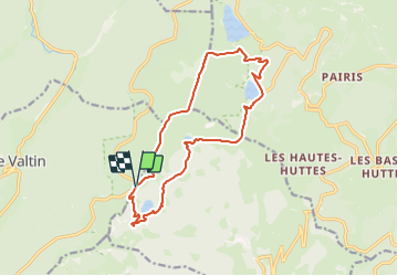

Length
14.3 km

Max alt
1302 m

Uphill gradient
599 m
Km-Effort
22 km

Min alt
952 m

Downhill gradient
602 m
Boucle
Yes
Creation date :
2023-10-25 08:22:52.265
Updated on :
2023-10-25 08:35:44.117
5h04
Difficulty : Very difficult

FREE GPS app for hiking
 SityTrail
IGN / Geographical institutes
SityTrail Plus
The world is yours!
About
Trail Walking of 14.3 km to be discovered at Grand Est, Vosges, Le Valtin. This trail is proposed by scaillet.
Description
depart le parking du Col de Dreieck ou Collet du Lac Vert (1225m) au bord de la D61.
Positioning
Country:
France
Region :
Grand Est
Department/Province :
Vosges
Municipality :
Le Valtin
Location:
Unknown
Start:(Dec)
Start:(UTM)
355596 ; 5328442 (32U) N.
Comments